Tools and Products

Overview
The Tools and Products (TAP) program aims to develop user-friendly software-based tools that enable industry to adopt and utilise outputs from CRCWSC Research. TAP assists in creating and/or evaluating various concept designs, technologies, or policy solutions to address and promote water sensitive objectives and outcomes across the urban development sector.
The suite of tools and products can broadly be categorised into visioning and concept planning (TAP 1), or city shaping and solutions (TAP 2 & 3). They can be applied by local councils, developers, water utilities, consultancies, government agencies and other organisations that need evidence-based data to aid in decision-making when mainstreaming water sensitive technologies and practises.
Continuous industry collaboration, including an industry-based project steering committee, has been crucial for each piece of software to inform the development, test and refine the functionality, and ensure it caters for the needs of the eventual end-user. Many Participant organisations have started using the tools and products, including some commercial case studies where the beta model of the Scenario Tool has been applied.
The major outputs from the project are described below.
TAP 1
TAP 1 consists of three key web-based tools; Water Sensitive Cities Index, Transition Dynamics Framework and the Management Actions Database. These tools are at various stages of development. The Water Sensitive Cities Index has been applied by more than 20 organisations being delivered by independent providers. If you are interested in learning more about these tools, please read TAP 1 below or contact Water Sensitive Cities Australia at admin@crcwsc.org.au.
The software tools developed for TAP 1 provide guidance on how to develop common water sensitive cities objectives and transition strategies and evaluate targeted interventions. The different tools may be accessed online and used together as a comprehensive suite or individually, as needed.
The WSC Index is a tool designed to benchmark a city’s current performance against the seven goals of a water sensitive city. These goals include both biophysical and socio-institutional goals, which are organised into 34 corresponding indicators. Each of the 34 indicators are scored on a 1-5 rating scale in a collaborative workshop process. The data is then entered into a web-based platform that can filter the results according to what is most useful for the user. The TAP program continues to update the software for providers to deliver the WSC Index service.
The TAP program has extended the Water Sensitive Cities Index to include:
- A Management Actions Database; this is an online tool that will support city comparison, diagnostic strategy setting, and prioritisation based on the WSC Index. It links to a management actions database, which will allow practitioners to specify management actions that facilitate water-sensitive futures.
- A Transition Dynamics Framework; this is an online tool to access the current enabling conditions and resources of an organisation in order to develop a high-level transition strategy.
These tools are currently under development with an aim to launch these tools before the end of 2020. If you are interested in learning more about the progress of their development, or would like to get involved in the development process, please contact Katie Hammer.
TAP 2 & 3 - WSC Scenario Tool
These work packages merged to produce the one web-based planning tool called the WSC Scenario Tool. The WSC Scenario Tool is a planning tool assess the multiple benefits of green infrastructure solutions. It comprises four rigorously tested analytical modules integrated within a powerful online geospatial modelling environment:
- Urban Development Module (BETA Release May 2019).
- Simple “Extreme Heat Day” Land Surface Temperature Module (BETA Release May 2019).
- The Air-temperature Response to Green/Blue infrastructure Evaluation Tool (TARGET) Module (BETA Release April 2020).
- Water Cycle Module (BETA Release September 2020).
Users can create personalised adaptation planning strategies and test them under dynamic what-if scenarios with a wide variety of stakeholders.
Webinar: TARGET module Launch and Panel Discussion
Webinar: Release of the updated beta WSC Scenario Tool and Urban Water Cycle module launch
Industry Note for Urban Water Cycle
For more detailed information, read more of TAP 2&3 below.
The WSC Scenario Tool is a planning-support tool that enables users to simulate urban development and the performance of water management interventions dynamically over time, including effects on the microclimate and urban water cycle. It is accessed online via a web browser, and utilises GIS to inform its modelling.
It can used by planners, designers, engineers and other related professionals to assess the multiple benefits of green infrastructure solutions in terms of their biophysical and ecological impacts in order to provide the basis for a robust water-sensitive business case. Users can create personalised adaptation planning strategies and test them under dynamic “what if” scenarios. The subsequent visualisations and results obtained facilitate engagement with a wide variety of stakeholders, and can inform business case development, decision making, planning and design guidelines and policy development.
The WSC Scenario Tool integrates multiple modules that can be run for scenarios.
Core Modules integrated:
- Land Surface Temperature; assesses land surface temperature.
- TARGET; assesses air temperature and human thermal comfort.
- Urban Water Cycle; simulates the different streams in the urban water cycle based on a conceptual hydrological model.
Additional Modules (to be integrated in the future):
- Economic Evaluation; integrates life cycle costing of WSUD options, and supports cost-benefit analysis (INFFEWS).
- Rapid Drainage Assessment; integrates a 1D hydrodynamic drainage model, to be available to expert users.
The WSC Scenario Tool provides the following features:
- User interface; an online web interface to set up scenarios and create 3D satellite-based maps and graphs to interactively explore results and communicate outcomes.
- GIS data; access to common GIS data (cadastral maps, building footprints), biophysical data, socio- demographic data and past and future climate data. Users can also upload their own datasets to enable customised case studies.
- Built form and green infrastructure; applies algorithms to generate urban built form, infill development, and green infrastructure based on scenario set up.
- Expert interface; enables the generation of complex scenarios via coding scripts, which is available to expert users.
The WSC Scenario Tool can be used for the following:
- Produce a Land Surface Temperature map for an existing area
- Create a realisation of pervious and impervious area for a newly developed precinct
- Compare the urban heat island effects of different development strategies
- Depict the multiple benefits of blue/green infrastructure
- Combine different environmental performance assessments normally undertaken in separate programs
- Enable representative demographic data for a specified region to be downloaded
For more information about the modules, and to request access to the tool, visit the Scenario Tool Website.
TAP 4
This work package outlines a commitment to engaging with stakeholders to develop user-friendly tools that will meet the expectations and needs of our industry partners. It ensures we are keeping our partners informed, and working with them in a collaborative way that ultimately empowers them to apply the tools in their own workplaces in order to inform their decision on planning, design and policy.
See WSC Scenario Tool Training website
For details and links to past training webinars, read more of TAP 4 below.
Stakeholder Engagement
TAP Leader, Dr Christian Urich, has engaged with stakeholders through seminars, conferences, workshops, meetings and participating CRCWSC Research and Adoption activities. He has been working with Participant organisations and other key stakeholders to promote the potential and capabilities of the tools and products, and the importance of the outputs for decision-making and better planning for water-sensitive outcomes. Together with the CRCWSC Commercial team, Dr Urich has completed several case studies using the current beta version of the WSC Scenario Tool, which has provided clients and partners with a comprehensive demonstration of the tool as well as aided the developers in refining and improving the next release of the software.
Regular communication is available via the CRCWSC website, WaterSENSE newsletter articles, TAP mailing list, TAP quarterly reports, TAP Project Steering Committee meetings, presentations to CRCWSC RAPs and at industry events. There will be national adoption seminars for TAP in July-Dec 2020 to coincide with the public-facing release of the updated CRCWSC Scenario Tool. To be added to the mailing list, please contact Tammie Harold at tamara.harold@uwa.edu.au
Training
The TAP team has developed an abundance of training material (available from the WSC Scenario Tool training website) to help the user prepare and apply the tool. This includes training webinars, information on data sets, a FAQ page, and background on the urban form and blue/green infrastructure adaption options, which will help inform the user on how to select the relevant parameters correctly.
The WSC Scenario Tool documentation are embedded within the help section of the WSC Scenario Tool's user interface and are regularly updated as the tool continues to develop.
Past Webinars
Training Seminar 1 - East Adelaide Case Study
Training Seminar 2 - Oxley Creek, Queensland
Training Seminar 3 - Townsville, Queensland
Training Seminar 4 – Western Melbourne, Victoria
Training Seminar 5 - City of Kingston
Training Seminar 6 - Truganina
Training Seminar 7 - Scenario Tool User Interface
Training Seminar 9 - Manage your data
Training Seminar 10 - Developing cooling strategies using the WSC Scenario Tool
Training Seminar 11 - Urban Water Cycle - Greenfield Development
Training Seminar 12 - Urban Water Cycle - Infill Development
Next Webinar
We aim to complete a training webinar each month.
If you would like to be invited to the next webinar, please register your interest with Tammie Harold at tamara.harold@uwa.edu.au
Testing Phases
Each newly integrated module undergoes a robust testing regime, which includes two separate testing phases. The individuals involved in the testing phases dedicate 10+ hours to attend several online training sessions, apply a provided case study to ensure that the guidance documentation and application of the tool is clear and easy to follow, employ their own case study with limited assistance, and provide evaluative feedback for the improvement of the tool and the related documentation.
Phase 1
A small group of three industry representatives are selected to undergo an initial round of testing for feedback on any major issues.
Phase 2
Once the initial feedback has been addressed, a User Acceptance Test group is established based on Regional Managers’ recommendations of relevant and engaged industry representatives from CRCWSC Participant organisations. This group consists of a range of practitioners from various organisations and usually aims to have 10-20 individuals. This round of testing helps to identify matters that would require further clarification for a broader audience, and other minor issues.
All feedback is carefully documented and is used to identify and prioritise the improvement/development required for the Scenario Tool. Yafei Zhu coordinates the testing phases. If you are interested in being a part of the external testing program, please contact your Regional Manager or Tammie Harold at tamara.harold@uwa.edu.au
From August 2020, we encourage CRCWSC Participants to trial the tool in their own case study. These case studies will serve to showcase the potential and extensive applicability of the tool. Users will be required to apply the tools themselves and attend online support sessions as part of the initiative.
If you are interested in applying the substantially improved Scenario Tool in your own case study, please contact your Regional Manager.
Case Studies
The following case studies were conducted using the initial Beta version of the Scenario Tool.
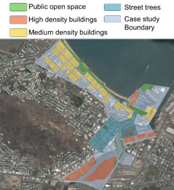
The Townsville City Council have recently established a Priority Development Area, which consists of a mix of medium and high density residential developments and public open space. Currently, there is a lack of uptake of water sensitive design solutions and practices. The Council, via E2Designlab, applied the CRCWSC Scenario Tool to model complex scenarios to better understand the implications on urban heat and water quality.
Scenarios were developed with a multiple adaptations for each, and are as follows: i) Baseline, ii) Business-as-usual (BAU) including (a) high-density and (b) medium-density residential development, and iii) WSUD interventions, which contained street trees, green roofs, rainwater harvesting tanks, lot trees, and open space irrigation.
The results indicated that compared to the BAU development, the WSUD interventions achieved a decrease of nearly 4 degrees in land surface temperature, and reduced total nitrogen by approximately 1,630 kilograms per year.
The Liverpool City Council is currently experiencing rapid economic, demographic and physical changes as Liverpool becomes one of the fastest growing regions in Sydney. The population is expected to almost double to more than 320,000 over the next 20 years. The Metropolitan Plan targets employment capacity of 31,000 jobs for Liverpool Regional City by 2036 per 2016 Master Plan Report. The CRCWSC was employed to support project stakeholders with ideas for a water-sensitive Liverpool Collaboration Area (LCA). The TAP team applied the CRCWSC Scenario Tool to demonstrate the benefits derived from a proposed greening program related to amenity value, the cooling effect, improved waterway health (sediment and nutrient reduction), and flood protection enabling public safety.
The Liverpool CBD area was selected, parameters agreed upon, scenarios set up and data collected. The solutions established included a business-as-usual (BAU) approach, and two water-sensitive alternatives of different intensity derived from the implementation of a greening program.
The land surface temperature and water cycle models were run for each scenario. The results showed a significant improvement over the BAU approach – for example, there was a 10 degree average reduction in surface temperatures on roads due to the greening program.
For detailed information, please read the Research Synthesis Report called Ideas for the Liverpool Collaboration Area.
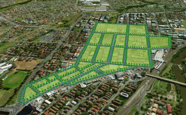
The Yarrabilba Community wants to create liveable places in their neighbourhood using water as the enabler. Yarrabilba is 2000 hectarea in area, with a population of approximately 50,000 and is currently experiencing ongoing urban development. The community is aware that the initial urban development phase has replaced forest with impervious surfaces thereby increasing the average surface temperature in the area. They employed the CRCWSC to improve their understanding of the biophysical aspects of designing a water-sensitive neighbourhood.
The TAP team set up scenarios that included the current arrangement (baseline), the business-as-usual approach to the urban area developments, and two differing scenarios adopting water sensitive elements, one with minor elements (50% open space irrigation, trees on 15% of lots, 25% uptake of rainwater harvesting tanks) and one with major elements (75% open space irrigation, trees on 25% of lots, 75% uptake of rainwater harvesting tanks plus the addition of swales and tree pits).
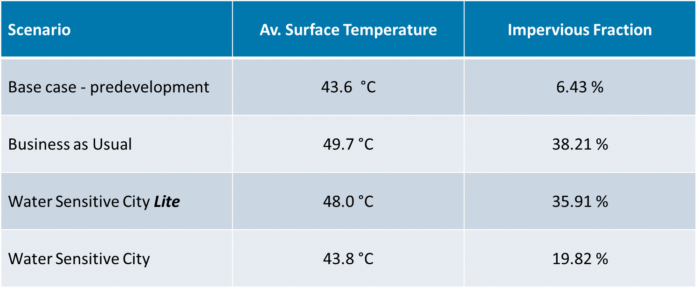
The Scenario Tool ran the relevant modules to obtain land surface temperature and impervious fraction outcomes for each scenario. The results provided evidence for the various levels of investment in relation to planning and decision-making (see box below).
Project Steering Committee
The TAP Project Steering Committee (PSC) incorporates individuals from CRCWSC participant organisations. Members provide input and feedback on the project over its duration, aiming to help the program achieve the best final possible outcomes for industry.
- Mr. Andrew Allan - Manningham City Council
- Mr. Martin Allen - Department of Environment and Water
- Prof. Jurg Keller - University of Queensland
- Mr. Rhys Coleman - Melbourne Water
- Mr. Nicholas Deeks - GHD
- Dr. Cintia Dotto - Melbourne City Council
- Assoc. Prof. Matthew Hipsey - University of Western Australia
- Dr. Steven Kenway - University of Queensland
- Dr. Sara Lloyd - E2DesignLab
- Dr. Keshab Sharma - University of Queensland
- Ms. Cath Thrupp - Brisbane City Council
- Mr. Gavin Winter - Queensland University of Technology
- Mr. Sadeq Zaman - Department of Planning, Industry and Environment
- Ms. Lorena Taylor - University of Queensland
- Mr. Luke McPhail - Water Technology
- Ms. Antonietta Torre - Water Corporation
- Ms. Ana Rubio - Hornsby Shire Council
For further information, send an email to the TAP project team.