Urban planning
Contact
Introduction
Good urban planning includes water as a key focus of decision making to enhance water security and waterway health, reduce flood risk and damage, and create spaces that collect, clean, and recycle water.
CRCWSC research emphasises the critical role urban planning plays in achieving water sensitive outcomes in greenfield development (not previously urbanised) and infill development (within existing urban areas).
Our research on the urban planning has identified some interesting findings:
- This thought piece sets out the agenda for transformative cities, and advocates using hybrid systems to drive this transformation. These hybrid systems combine critical existing infrastructure with flexible decentralised local solutions as part of their urban renewal program. (Harnessing hybrid systems for transformative cities)
- Urban planners can incorporate water sensitive outcomes into planning, design and management to provide multi-value benefits including flood resilience. (Flood Resilience in Water Sensitive Cities: Guidance for enhancing flood resilience in the context of an Australian water sensitive city)
- Statutory planning that uses quantitative targets and encourages street scale application increases the adoption of water sensitive urban design. (The Influence of Statutory Land Use Planning on Water Sensitive Design Practices)
- The urban metabolism evaluation framework can support urban planners to integrate stormwater, wastewater and drinking water into development assessments and strategic and land use planning. (Urban metabolism for planning water sensitive city-regions Proof of concept for an urban water metabolism evaluation framework)
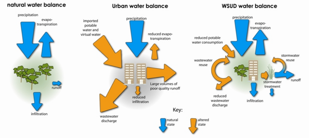
- An urban infill development study discovered water sensitive housing principles can increase dwelling density from 28 to 42 per hectare, without further impacting stormwater runoff, infiltration or evapotranspiration. (Quantifying the hydrological performance of infill development)
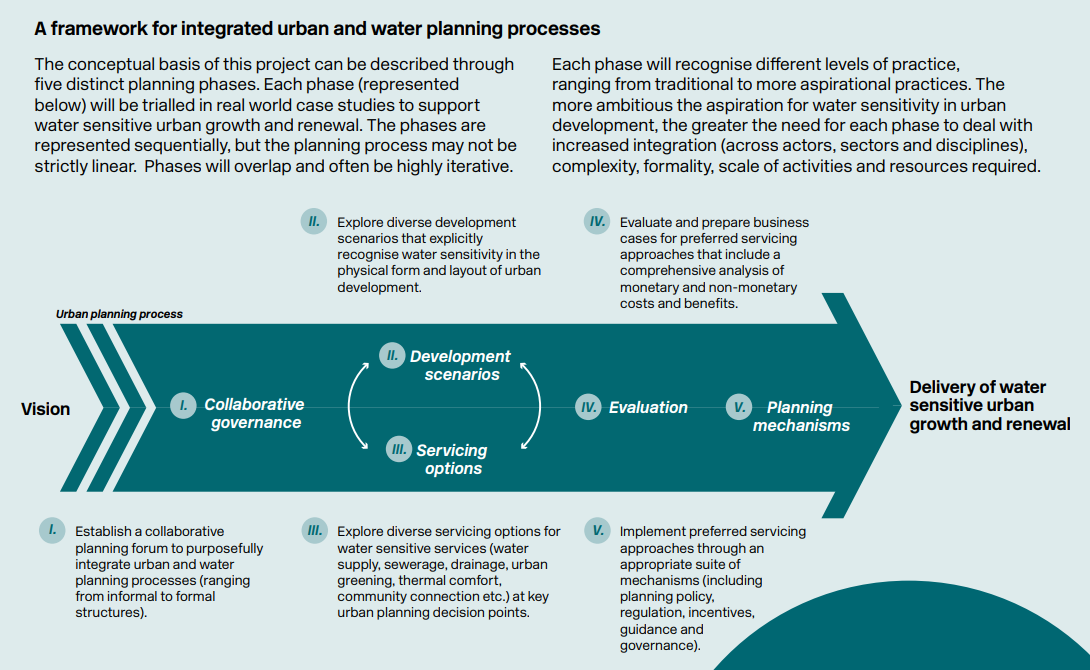
- Successful integration of urban planning and water planning should include the five phases of collaborative governance, development scenarios, servicing options, evaluation, and planning mechanisms. (Guiding integrated urban and water planning)
- We propose 11 targeted planning and governance opportunities to support the delivery of water sensitive urban development in Perth. (Enabling water sensitive urban development: planning and governance opportunities for Perth)
- We propose 14 specific opportunities to strengthen Townsville’s planning and governance systems to advance its water sensitive agenda. (Enabling water sensitive greenfield development in Townsville)
You will find a range of research reports on urban planning under the categories below.
You will find a range of research reports on urban waterways under the categories below.
Land use planning
- The Influence of Statutory Land Use Planning on Water Sensitive Design Practices
- Understanding social preferences for land use in wastewater treatment plant buffer zones
- Are we there yet? Integrated water sensitive open space planning for climate change adaptation
- Modelling interactions between lot-scale decentralised water infrastructure and urban form – a case study on infiltration systems
- Facilitating water sensitive urban development through planning integration
Strategic planning
- Preparing for disruptions: A diagnostic strategic planning intervention for sustainable development
- A methodology to enable exploratory thinking in strategic planning
- A strategic program for transitioning to a water sensitive city
- Diagnosing transformative change in urban water systems: theories and frameworks
- Design of the public realm to enhance thermal comfort
Water planning
- Urban metabolism for planning water sensitive city-regions Proof of concept for an urban water metabolism evaluation framework
- Quantifying the hydrological performance of infill development
- Guiding integrated urban and water planning
- Flexible adaptation planning process for urban adaptation in Melbourne
- Flexible adaptation planning for water sensitive cities
- The impact of urbanisation and stormwater management practices on water balances and nutrient pathways in areas of high groundwater: a review of recent literature
- Analysing water sensitive urban design options
- Strengthening the delivery of WASH in urban informal settlements: addressing multiple exposure pathways in urban environments
- Water in the city: Green open spaces, land use planning and flood management – An Australian case study
- Site-scale Urban Water Mass Balance Assessment (SUWMBA) to quantify water performance of urban design-technology-environment configurations
Flood planning
Research application
Our research on urban planning has been applied to a range of projects:
- The Scenario Tool worked example: Highett Gasworks demonstrates how the tool was used to assess how various development options will impact urban heat and the water cycle in a hypothetical development at the Highett Gasworks.
- A range of mechanisms were proposed to manage future development in the Sydenham to Bankstown Urban Renewal Corridor, including planning principles that integrate water management and urban spaces.
- Stakeholders applied a co-design approach to position water as key component in the renewal of the Liverpool Collaboration Area in New South Wales.
- Ideas for Vic. Planning Controls outlines approaches to apply planning controls to improve stormwater management in Victoria.
- The 485 hectare urban renewal project at Fishermans Bend created innovative outcomes for urban planning and water management.
- The design concepts developed for the urban redevelopment precinct at Arden Macaulay integrate landscape form and climate change adaptation to influence development scenarios and building design.
Tools and guidelines
Several tools and guidelines, informed by our research, have been developed for use by practitioners including:
- Practising integrated urban and water planning describes a framework and series of principles for integrating urban and water planning, illustrated with case examples from across Australia.
- The Infill Typologies Catalogue provides urban planners with evidence-based design guidelines to support better residential infill practice. The catalogue has a range of housing densities and configurations and evaluates their water sensitive performance.
- The Flexibility in Adaptation Planning guideline provides a step-by-step approach to increase resilience against climate related flood hazards allowing urban planners to identify adaptive responses.
- The Water Sensitive Cities Index, an innovative city benchmarking and planning tool, helps city planners and decision makers transition to a water sensitive city.
- Trees for a cool city provides an illustrative guideline for planning and prioritising street trees to achieve the largest cooling benefits for human thermal comfort.
- The Adaption tipping points tool (ATP) supports urban planning and land use decisions by improving confidence in flooding system performance through stress testing a range of failure points over time.
Infographics
Infographic 1
An example of urban metabolism (CRC for Water Sensitive Cities, 2019. Ideas for the Liverpool Collaboration Area. Melbourne, Australia: CRC for Water Sensitive Cities, p. 23.)
Infographic 2
Tree pits provide passive watering for trees (CRC for Water Sensitive Cities, 2019. Case study: Dubbo urban heat island amelioration project. Melbourne, Australia: CRC for Water Sensitive Cities, p. 15.)

Infographic 3
A framework for integrated urban and water planning processes (CRC for Water Sensitive Cities, 2018. Integrated Research Project 3: where water planning meets urban planning. Melbourne, Australia: CRC for Water Sensitive Cities, p. 1.)
Infographic 4
Influence of infill development on water performance (CRC for Water Sensitive Cities, 2018. Overview: IRP4 – Water sensitive outcomes for infill developments. Melbourne, Australia: CRC for Water Sensitive Cities, p. 2.)

Infographic 5
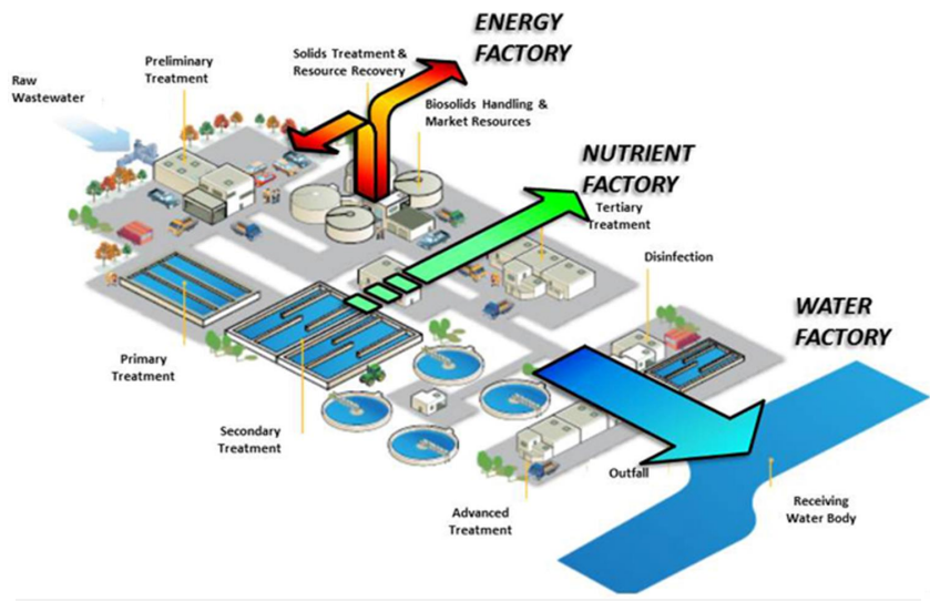
Figure 2. The concept of urban metabolism (Renouf MA et al., 2016. Urban metabolism for planning water sensitive cities: concept for an urban water metabolism evaluation framework. Melbourne, Australia: CRC for Water Sensitive Cities, p. 14.)

Infographic 6
Figure 3. Urban metabolism of water (Renouf MA et al., 2016. Urban metabolism for planning water sensitive cities: concept for an urban water metabolism evaluation framework. Melbourne, Australia: CRC for Water Sensitive Cities, p. 14.)
Infographic 7
Elements of statutory land use planning (Choi L and McIlrath B, 2017. Policy framework for water sensitive urban design in 5 Australian cities. Melbourne, Australia: CRC for Water Sensitive Cities, p. 15.)
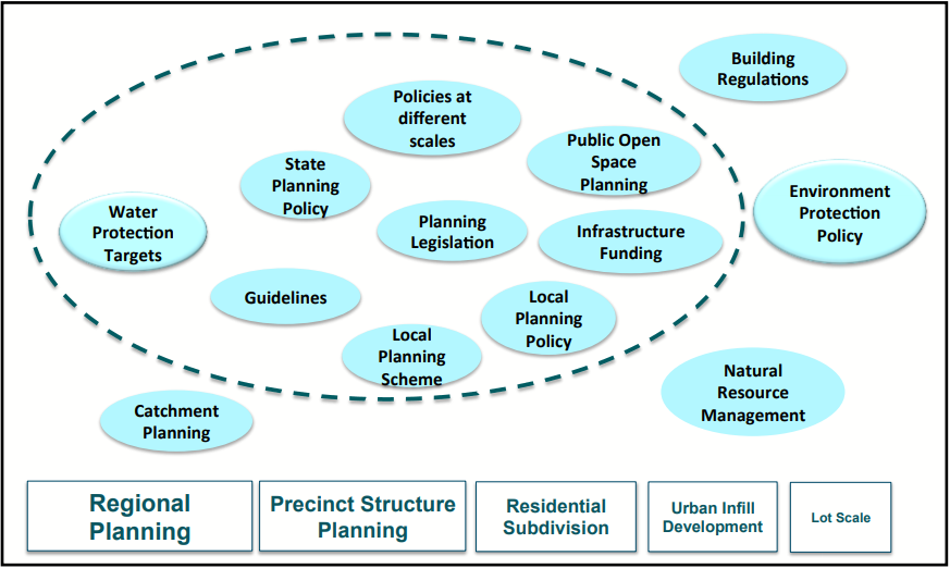
Infographic 8
State planning policy for WSUD: the current legislative and policy framework for land use planning in NSW (Choi L and McIlrath B, 2017. Policy framework for water sensitive urban design in 5 Australian cities. Melbourne, Australia: CRC for Water Sensitive Cities, p. 69.)
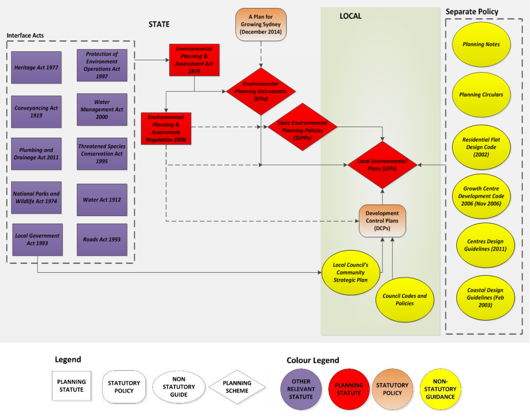
Infographic 9
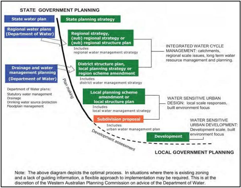
Urban Water Management Plans – Guidelines for preparing plans and for complying with Subdivision Conditions, Integrating water planning with the land planning process in WA (Choi L and McIlrath B, 2017. Policy framework for water sensitive urban design in 5 Australian cities. Melbourne, Australia: CRC for Water Sensitive Cities, p. 102.)
